
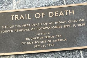
The first death during the forced removal and march was that of a child on September 5, 1838. This is a small portion of the tragic story of greed, western expansion, and lies that became known as the Potawatomi Trail of Death.
On September 4, 1838, 859 Potawatomi Indians were forced to begin a 660-mile march from Twin Lakes, Indiana, near present-day Plymouth, to a reservation in what is now Kansas. The march lasted until November 4, 1838, with 42 Potawatomi dying along the way. Conditions were harsh and grueling. Water was scarce, and without enough horses, even the elderly were forced to walk. The promised wagons never arrived. Sixty-one brutal and tragic days later, they arrived in Kansas.
The State of Indiana and the federal government desired to expand westward through northern Indiana. In 1832, construction of the Wabash Canal had begun in northern Indiana, with the plan to connect it with the Erie Canal. White settlers were moving into the area, and lands the Potawatomi lived on were now needed by the government. Although many Potawatomi had already moved peacefully west, on August 5, 1838, Chief Menominee and his tribe at Twin Lakes remained steadfast. This date was the deadline to leave the lands, as set in a treaty from August 5, 1836. Chief Menominee never signed the treaty and claimed the signatures were forged.
Indiana Governor David Wallace sent General John Tipton with a militia to surround the village and forcibly remove Chief Menominee and his band. On September 4, 1838, the march began when the militia burned the crops and the village so there would be nothing left if the people attempted to return. When they arrived at Pottawattomie Creek in present-day Osawatomie, Kansas on November 4, 1838, the Indian Agent and the promised cabins were not there. The Potawatomi spent the winter in ravines 20 miles south at Sugar Creek.
The marker noting the death sits alongside Mud Creek a few miles south of Rochester, Indiana, on State Road 25. There is a small bridge passing over the creek, and the marker can be difficult to see when driving at highway speeds. Parking is next to the guardrail. The footing can be rough on the short walk through a ditch to the marker.
Today, there are over 70 markers tracing the route from Indiana through Illinois and Missouri, ending in Kansas.