
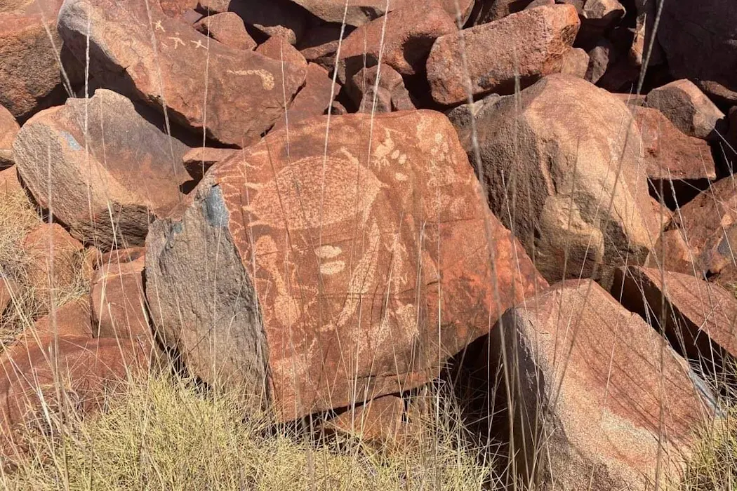
Murujuga is a sacred cultural landscape of land and sea Country across the Burrup Peninsula and Dampier Archipelago, in Western Australia’s Pilbara region.
It contains an estimated 1 million to 2 million petroglyphs, or rock engravings, that tell the story of the relationship between Ngarda-Ngarli Traditional Owners and this landscape over at least 50,000 years. These petroglyphs hold deep meaning for Ngarda-Ngarli, embodying cultural, spiritual, ancestral and environmental knowledge.
In July 2025, the Murujuga Cultural Landscape was added to the UNESCO World Heritage List in recognition of its outstanding cultural and spiritual significance. This brought renewed attention to Murujuga, which exists alongside longstanding industrial complexes that process commodities such as liquefied natural gas (LNG). Concerns have been raised that industrial pollution is degrading the rock art.
At the heart of our work is a question: how can this extraordinary place, and the rock art it contains, be protected into the future?
Today we released the third annual peer-reviewed report of the Murujuga Rock Art Monitoring Program (MRAMP). This government-funded research effort doesn’t resolve every question – understanding a system as complex as Murujuga takes time. The research is undertaken by a team of more than 30 multidisciplinary researchers, and independently peer reviewed by a range of international experts. It is solely written by the researchers.
This work gives us a clearer picture than ever before of what’s driving changes observed in the rock surfaces.
MRAMP rangers change samplers at an air quality monitoring station. Ben Mullins A shift in the evidenceLast year we found some rock surfaces near industrial areas showed increased surface porosity, meaning there were measurable structural differences compared with rocks further away. These rocks have weathered or deteriorated more, and may be at greater risk of fading or flaking if this continues.
This year, we used an expanded dataset to build a more complete snapshot of porosity across Murujuga. Importantly, both datasets told the same story: there is a statistically significant porosity pattern across the peninsula, with higher porosity being found closer to industrial sites. Put simply, rocks closer to industrial sites are more porous than those further away.
Earlier monitoring pointed to nitrogen dioxide, the most abundant air pollutant gas at Murujuga, as a possible cause. But our data at the time couldn’t clearly separate its effects from other air-borne pollutants, particularly sulphur dioxide.
This year’s results change that picture. Several lines of evidence – atmospheric chemistry, rainfall pH and laboratory testing – now point to historic levels of sulphur dioxide from a range of industry and shipping, and the acid rain it can produce, as the most relevant factor.
The chemistry behind this is well understood: sulphur dioxide reacts in the atmosphere or on the rock surface to form sulphuric acid. This can dissolve the manganese and iron oxide minerals that give the rock varnish its dark colour, to create porosity.
Historic emissions the problemThese findings are significant, because sulphur dioxide emissions have fallen sharply since the 1980s, both at Murujuga and globally. Our evidence suggests it was historic peaks in sulphur dioxide, rather than current emissions, that made these rocks more porous.
It’s likely this process acted in conjunction with microbial activity on the rock surface.
Working out how those factors interact is a key task for our fourth and final report, out next year. Experiments to date suggest ammonia may influence some of the chemical and biological processes occurring on rock surfaces. However, current evidence suggests industrial ammonia emissions are too recent to explain the long-term porosity pattern observed across Murujuga. Historic sulphur dioxide remains the strongest explanation supported by the available evidence.
This conclusion rests on a large body of evidence. Across three years, we’ve measured rock surface condition 186,000 times. And these results have been backed by air quality monitoring across the peninsula, continuous rainfall chemistry sampling, and more than 5,500 laboratory tests on rock samples.
Together, they point to the same conclusion: the elevated rock porosity is most consistent with historic sulphur dioxide emissions, rather than current air pollution.
Rock art of terrestrial and marine fauna at Murujuga. Ken Mulvaney What about current air pollution?This is the question we’re asked most often. It deserves a careful answer.
During monitoring, we did not observe acid rain. Air quality has generally remained below environmental thresholds developed through our program. We have not found measurable acceleration of rock deterioration linked to current pollution. However, this is different from proving that no effect, however small, could ever occur.
All rock weathers naturally over time, and monitoring can only rule out effects large enough for current methods to detect. Other researchers, working with different experimental methods and smaller sample numbers have reached different conclusions.
Our research is built on three years of continuous, multidisciplinary monitoring, rather than a single study.
What happens now?Damage to landscapes such as Murujuga rarely have a single cause. We’re tracking how many factors interact, sometimes over decades.
The fourth and final year of this research will focus on the interplay of air quality, rock surfaces and microbial communities. We will also complete the environmental criteria to protect Murujuga in the long term, with a focus on ammonia and ozone, in addition to sulphur dioxide and nitrogen dioxide. However, ongoing monitoring will continue to ensure the protection of the rock art.
Murujuga has been cared for by Ngarda-Ngarli for more than 50,000 years. Our hope is this evidence continues to support that stewardship, and helps protect this extraordinary cultural landscape for many generations to come.
The Murujuga Rock Art Monitoring Program is funded by the WA Department of Water and Environmental Regulation.
Ben Mullins receives funding from the Department of Water and Environmental Regulation (Government of Western Australia) as part of the Murujuga Rock Art Monitoring Project.
Belinda Churnside serves as a director of Murujuga Aboriginal Corporation (MAC). She is also employed by MAC as the cultural advisor, a role within the Murujuga Land and Sea Unit (MLSU). This position is funded by industries operating within the Burrup and Maitland Industrial Estate Agreement (BMIEA) area. MAC receives funding support from both state and federal government departments, as well as from industry partners operating within the BMIEA area. The Department of Water and Environmental Regulation provides operational and strategic support for the Murujuga Rock Art Monitoring Program. All funding sources and expenditures are reported in MAC’s annual financial report.
Katy Evans receives funding from the Department of Water and Environmental Regulation as part of the Murujuga Rock Art Monitoring Project.
Nicola Armstrong receives funding from the Department of Water and Environmental Regulation as part of the Murujuga Rock Art Monitoring Project.