
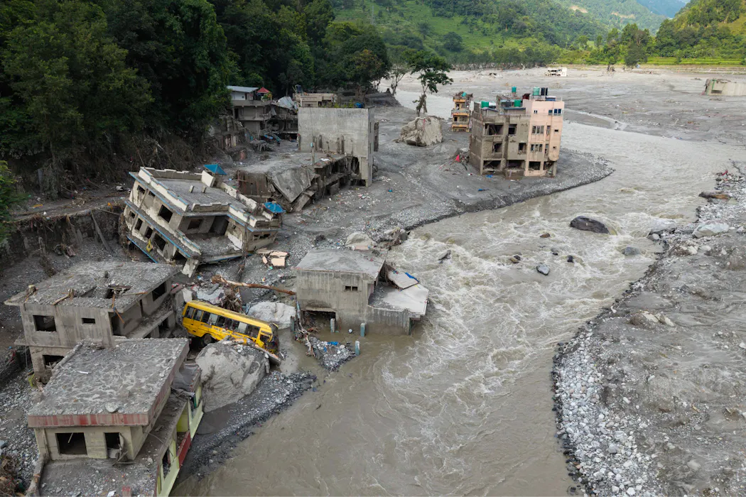
On the morning of August 26, a section of mountain near Langtang Lirung peak in Nepal suddenly collapsed.
A huge mass of rock, ice and debris plunged roughly 1,200 metres into the valley below, producing a hugely destructive flood on the Lhende Khola river. The flow travelled almost 100 kilometres downstream, washing villages and bridges away. Almost 1,000 people died and thousands more are still missing across the Nepal-China border.
What caused it? At first, it looked like a glacier collapse. But emerging satellite and photographic evidence suggests a more complex picture – an avalanche of rock and ice, rather than a simple glacier collapse.
The mountain face now has a sharply defined scar after the collapse, clearly marking the boundary between the remaining slope and the section which failed.
This isn’t the first rock-ice avalanche in the Himalayas, but it is by far the most devastating. Unfortunately, it is unlikely to be the last. Rising temperatures due to climate change mean the permanently frozen slopes of mountains in the region may begin to melt and destabilise.
How did a mountain collapse?The steep mountain face was topped by a glacier – a heavy river of ice. It’s likely that the steep slope of bedrock collapsed first, followed by the overhang of ice.
As this enormous mass fell into the valley, it created a tremendous amount of energy. This would likely have melted the ice in the avalanche and any in the valley, adding large volumes of faster-moving water to the flow and intensifying the debris flood.
The rugged Himalayan terrain made the disaster even worse by providing a steep, confined pathway, accelerating the mass of water, rock, dirt and ice as it flowed into the river.
A landslide followed the first collapse and a small lake has formed within the newly created depression in the valley. The site will remain unstable for some time.
Now that we know more about how the Langtang collapse became a cascading disaster, we can find parallels.
The closest example is the February 2021 rock-ice avalanche in Chamoli, India, which began when a huge landslide down Ronti Peak triggered an avalanche carrying an estimated 27 million cubic metres of rock and ice. This became a fast-moving debris flowing down a river valley. Over 200 people were killed or left missing.
The high mountains are changingThe Himalayas are the best known feature of the High Mountain Asia region – a large area with an average elevation of 4,000 metres which includes mountain ranges and the Tibetan plateau.
Despite its height, the region is not safe from climate change. In fact, change is happening faster here.
As air temperatures warm past 0°C more often, glaciers are beginning to melt. Snow and rainfall patterns are changing.
Permafrost – long-frozen earth and rock – is also becoming vulnerable. This matters most for steep mountain slopes, where fractured rock can be held together by ice.
When the ice melts, these ice-rock bonds can break. Water can begin to move down through long-frozen mountain slopes and bedrock. That means long-stable slopes can suddenly fail.
It’s common to picture glaciers as a slow-moving river of ice in a valley. But this high region is home to many hanging glaciers and smaller ice masses perched on steep mountain slopes.
These are at particular risk because they often sit high above valleys. If their rock support collapses, they can too. If they take rock, sediment and water with them, a simple glacial collapse can become a much larger avalanche or debris flow.
As the climate heats up, warmer air can lead to faster melting of the glacier and change how tightly it is coupled to its rocky bed. A small change in conditions at the glacier’s base can make it unstable.
Which areas are at highest risk?Predicting the next big mountain or glacier collapse is a very complex task.
But we can improve our understanding of the landscapes and environmental conditions associated with such failures. Recent analysis of large rock and ice avalanches across the High Mountain Asia region gives us important insight.
Of the 60 avalanches analysed, 86% began on slopes steeper than 30° and at elevations above 3,000 metres. Almost two-thirds (65%) began in areas where permafrost was probable.
Earthquakes, underlying rock types and structures, and changes to rainfall can also make these avalanches more likely.
Across this region, rock–ice avalanches have been documented to occur more often in the Western Himalayas, including the Karakoram and Pamir Ranges, and across southern and eastern Tibet.
We will need to treat these rock-ice avalanches as a cascading hazard separate to isolated glacier collapses or landslides.
Could we be forewarned?Footage from the disaster shows many people were caught unaware. If we could predict which glaciers or mountain faces are at highest risk, we could potentially save lives.
It is not an easy task. Signs a collapse is imminent such as rock deformation or fractures can often be subtle.
One approach could be combining field observations and seismic monitoring with data from satellites equipped with sensors able to observe changes in mountain faces and make optical and thermal infrared observations. New techniques such as the use of drones to monitor inaccessible or dangerous terrain are also worth exploring.
Observations must feed into early-warning systems capable of rapidly communicating the danger to communities downstream.
Because many Himalayan rivers cross national boundaries, nations will have to work together to strengthen data sharing, joint monitoring and coordinated early-warning systems.
The task is increasingly urgent. Climate change is loading the dice for more disasters in this high, cold region.
Tirthankar Ghosh is affiliated with the Indian Institute of Technology Bombay.
Levan Tielidze receives funding from the Australian Research Council's Special Research Initiative on Securing Antarctica's Environmental Future.